As part of a talk in December, 2000, I presented a list of my top
ten day hikes on trails in Southern Arizona (broadly defined as being from
level with Phoenix, downward.) There has been one change to the list since
then.
General safety notes: take extra food and water, a map, extra non-cotton
clothes, flashlight and safety equipment. There is a chance on hikes
1-6 that you will not see
anyone else, even on weekends. On weekdays, most of these hikes will be more
or less deserted. Take special care on hikes 1 and 2.
Here they are, with directions and notes, in reverse order:
10) Cochise Stronghold
(chaparral, with shade and often water)
Directions (recommended): You may need a little extra clearance to drive
this way, but it's worth it. Or consider carrying a shovel to level things
out on the road. Drive I-10 to Benson, turn off towards Tombstone. Just
before you get to Tombstone, turn left on (signed) MiddleMarch Road. Go
down this road over a number of cattle guards; turn left on a Forest
Service Road just after a cattle guard (about 15 minutes from the
highway). Follow this road to its end (another 20-30 minutes, 6 or 7 miles)
about a mile
after a ranch in a forested canyon. This is the section of road that can
cause problems for
normal clearance cars. The trail is obvious. Hike for as long as you want,
then turn around. You can also reach the other end of the trail by
following I-10 to Dragoon and following generally better dirt roads. Look
at your road map.
This hike is possible at all times of the year, if you don't mind heat and
cold (possibly including snow).
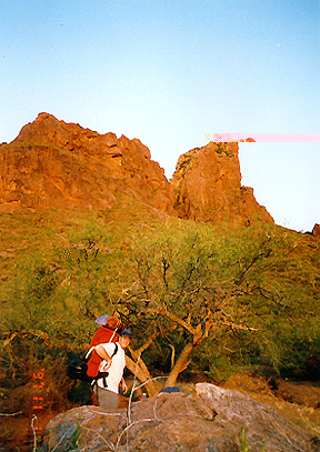
9) The Catalina front range
(low desert to pine forest, shade but no water)
This is the long version: shortened versions are obvious if you look at the
map. From Pima Canyon trailhead, hike up Pima Canyon to the top of Mt
Kimball. Admire the view. Descend towards finger rock canyon, turn left at
the intersection. Descend to a saddle - the trail is vague here - then
traverse along the trail to the Ventana canyon trail (obvious). Hike up to
the Window. Admire the view. Continue up this trail to a saddle, then
descend the Esperero trail down Esperero trail and into Sabino
Canyon.
Total distance over 20 miles. You will need to take a flashlight. All of the trails up into the front
range are worthwhile but a bit similar. Everyone should visit the Window at
least once. To hike there and back via Ventana canyon is a very enjoyable
day out (maybe 6-7 hours). Picture.
8) Aravaipa Canyon
(low desert but with shade and lots of water)
The first thing you need to do is call the BLM in Safford and get a permit
- you need one even if you are not camping. The permits are released
something like 90 days ahead. I would call 100 days ahead and find out when
to call back. They are often all taken within a few days of becoming
available. But surprisingly, the canyon didn't seem to have the 50 permit
holders it should have had when I went there. There's a campsite at the
trail head. When you get your permit, they'll send you a map which gives
directions, rules, etc.
Drive up past Oracle and Mammoth and along the San Pedro to the sign for
Central AZ Community College Winkelman (actually a few miles before
Winkelman). Turn right here and drive a few interesting miles to the trail
head. Normal clearance cars are fine.
This hike is really easy. You will be in the stream bed most of the time,
so take the right shoes.
7) Mount Wrightson
(chaparral to pine forest, some shade, probably no water)
Drive to Green Valley and then up to Madera Canyon. Hike up the Old Baldy
trail to the Josephine saddle, then up to the summit (surprisingly
quickly!) I recommend you descend the more gentle Super trail back to your
car, for a change of scenery. The summit view is spectacular.
Photo
Photo (yes, that's a bear. The question is whether it's the same bear that subsequently mauled people in this area.)
Photo
Allow most of a day.
6) Rincon Peak
(chaparral to pine forest, some shade and water)
Drive E on I-10 to the Mescal Road intersection. Go North, forking right
once you leave the town. Follow the dirt road over numerous washes
(probably high-clearance following rain) for a while until you see the sign
for the trailhead on the left. From the trailhead follow the trail into the
national park (about 1 mile) and then steeply uphill into a saddle. Turn
left at the junction and walk gently downhill into beautiful pines about 1
mile to the next intersection, where you turn left. If you carry on at the
intersection there's a tiny campground run by the NPS. After turning, the
trail continues a few miles to the top. It's hellish steep near the top.
We did this hike in December. We left Tucson around 6am, did the hike, and
were back in Tucson around 7pm. It might be a nice idea to camp at the
trail head either before or after.
5) Table Top
(low desert, no shade or water)
Drive north on I-10 to the junction with I-8. Go West on I-8 to Vekol Road
(about 20 miles). Go south. From here getting to the trailhead requires
care and may not be possible or advisable in a normal car. A map will help.
From the trailhead follow the trail up and back. Allow a good day
especially if you end up walking part of the way to the trail head.
4) Sycamore Canyon
(chaparral, some shade and water)
Drive down I-19 most of the way to Nogales. Turn right at the Ruby Road
(Pena Blanca Lake) exit. Continue on the paved road to the campground at
the bottom of the hill a couple of miles before the lake. Drive through the
campground on the dirt road, and continue a number of miles until the sign
for Sycamore canyon. Go a little way down this spur and park at the
end. Follow the trail into the canyon. After that it's a rock-hop most of
the way to the border. At the narrow part, climb around to the right (easy
but be careful - people have been injured here) or swim/wade. At the border
fence, turn around.
Again, give yourself a good day to do this. The hiking is easy but
gradually wears you down as you hop from rock to rock.
Photo
Photo
Photo
I haven't done this, but I think it would be interesting (after hiking) to
carry on to Ruby and eventually to Arivaca, on the Ruby Road. Just on the
East side of Arivaca there's a marsh with a really nice short trail for
birdwatching.
3) Salome Canyon / Jug
(low desert, no shade, plenty of water)
Drive north to Globe (2 hours). Go towards Miami, then turn onto 287
towards Roosevelt lake. Go all the way past the lake on its West side, then
turn right on a dirt
road (label??) and drive immediately across a wash. The road inexplicably
becomes paved again. Turn left off the pavement and drive around (and well
above) the East side of the lake until you reach the sign and parking area
for Salome Canyon (no good camping here). (about 10 or so miles from the
highway) From here follow the trail a
couple of miles until you reach a corral in the canyon. Go another 1/2 mile
up the canyon on the trail and drop into the stream where it seems
convenient to do so. Descend the canyon, swimming and wading as
necessary. You will not be able to get past a
big dropoff unless you have a 60ft rope or you are prepared to jump (not a good
idea). Don't worry, the canyon opens out very shortly after the rappel so
you won't have missed much if you choose to turn back here.
Do this hike early in the summer!!! It's green and smelly later
on. Be cautious if the water is flowing high. From Tucson the drive is
about 3 1/2 hours, the hike and return take maybe 5 hours. It's nice to
camp in the canyon too. Also hiking upstream from the trail end is very
good. Once you get back to your car you can continue on the road in the
same direction (South) and hit the road that leads up from the South end of
the lake towards Young, so making a circuit of the lake.
2) Ajo Peak
(low desert, no shade or water)
Go to Organ Pipe National Monument (2 1/2 - 3 hours). Talk to a ranger at
the visitor centre. Drive along the Eastern scenic drive to the Bull
Pasture trail. Hike up this steep trail to its end at an overlook. You will be
facing a big bowl. The trail skirts the bowl to its right
and heads up just to the left (North) of some amazing rock fingers (about
1/2 mile from the overlook). It then
traverses back along the ridge in front of you to the rocky summit. Descend
SE from the overlook onto the trail. Once you find it it's a good trail. It
gets steep near the rock fingers but is much easier above. The summit is
fabulous. Give yourself all day to do this one if you can. The hike is
steep in places but not too hard.
1) Kino Peak
(low desert, no shade or water)
Go to Organ Pipe National Monument. Talk to a ranger at the visitor
centre. Drive back out of the monument northwards, and turn towards Ajo at
Why. Then take a left before Ajo onto a dirt road which skirts a big
mine. The dirt road leads you back into the NW corner of the monument. Park
at Bates Well (an abandoned ranch). From here you are aiming to go between
the main massif (South) and a small hill (about WSW of the ranch). By the
time you get to the small saddle between these points, you will have found
a trail. A topo map (sold at the visitor centre) will come in extremely
handy here! After the saddle, follow this trail up the broad valley, almost
due South. After an hour or so you will come to the head of the
valley (and great views). From here, you need to hike directly up the hill
to the West (no obvious trail). After
some huffing and puffing you will find a strange "crater" and cairns
leading up the ridge to the South. Follow the cairns! They will lead you
along an entertaining ridge,
down a very steep gulley, then around a steep slope and finally onto a
beautiful summit ridge. Descend the way you came.
This might take 7-9 hours in total. At no point on this trail should you
be in fear - if you are, retreat and find the trail - it takes you through
some very steep areas in safety.
Also highly recommended:
Seven Falls
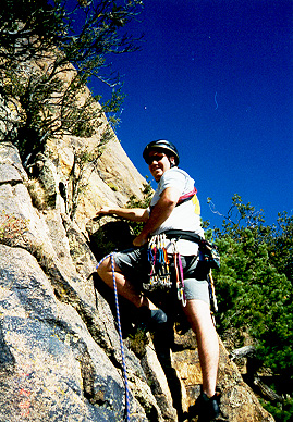
Baboquivari Peak (rock climbing). Picture.
Picture. Picture.
Picture.
White Canyon
Romero Pools